Scientists are embarking on a voyage of discovery today to map a previously uncharted section of the Colville Ridge, a large and mountainous seafloor structure about 500km northeast of Auckland.
More than half of the Colville Ridge, which covers an estimated 100,000km2, sits within New Zealand's The three week voyage is being undertaken by GNS Science, and takes place on NIWA's deepwater research ship Tangaroa as part of a long-term programme to survey regions within New Zealand's offshore territory.
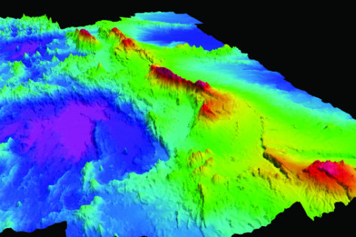
The Colville ridge. Photo: GNS Science.
Scientists will use sonar mapping, measurements of gravity and magnetism, supplemented by seafloor rock sampling to map the ocean floor. The techniques complement each other and are considered essential to obtaining meaningful information about the seafloor and its underlying geological structures.
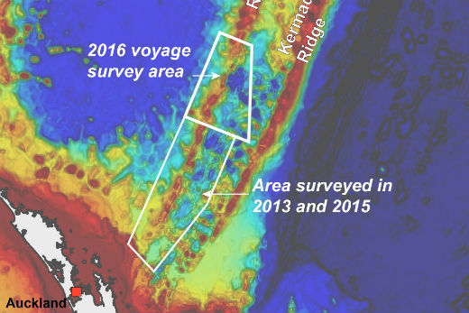
The mission builds on two earlier voyages, in 2013 and 2015, that mapped 40,000km2 of the southern parts of the Colville Ridge. The maps produced during these voyages show a vast mountainous ridge dotted with extinct volcanic cones and peaks rising 1.5km above the surrounding seafloor.
Co-chief scientist on the voyage, Fabio Caratori Tontini, says the crew is looking forward to discovering the submarine landscape of the northern part of the ridge.
The voyage will produce the first comprehensive, high-definition seafloor map, geophysical data sets and rock samples along the northern section. The information will provide new knowledge and understanding about the region's ancient volcanism.
The Colville Ridge is millions of years old and represents a key piece to better understand the geological puzzle of the region, which includes determining the role of plate tectonics in shaping the ocean floor in the northern part of our EEZ.
Christian Timm, the other co-chief scientist on the expedition, says understanding the formation of the Colville Ridge will give scientists valuable information to improve the understanding of the tectonic evolution of New Zealand's vast underwater estate.
'Together with the data from the two previous expeditions, we will have acquired new maps covering about 60,000km2 of ocean floor, which is equivalent to the size of Ireland or half of New Zealand's North Island,” says Christian.
'These surveys will allow us to strip away the seawater and view New Zealand's stunning underwater landscape in 3D. The new data will provide a framework for future studies that will include the deployment of underwater craft such as autonomous underwater vehicles (AUVs) and remotely operated vehicles (ROVs) to explore the seafloor in more detail.”
The older Colville Ridge and neighbouring Kermadec Ridge have formed as a result of subduction of the Pacific tectonic plate underneath the Australian plate. Both ridges stretch northeast from New Zealand towards Fiji and Tonga respectively.
There are four or five major ridge features in New Zealand's offshore territory and the Colville Ridge is arguably the least known of them.
The voyage draws on Ministry of Business Innovation and Employment funding for the Tangaroa, while funding from GNS Science covers equipment and scientific staff on the vessel.
Twenty one days of mapping. Photo: GNZ Science.

0 comments
Leave a Comment
You must be logged in to make a comment.