A mixed weather week kicks off today with a brace of hazardous and potentially damaging weather conditions across New Zealand.
An active front is sweeping up the country, bringing a risk of thunderstorms and heavy rain to Auckland, Wellington and the west of both Islands.
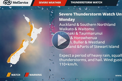
A thunderstorm watch is in place for Auckland, Southern Northland, Waikato and Waitomo.
There will also be severe gales in the east from the Wairarapa southwards, and snow down to 700m in the south.
Things are looking a bit more settled in the Bay, with the MetService predicting the odd shower turning to late rain this afternoon.
According to the weather organisation's five day forecast, tomorrow will be mostly sunny before more rain moves in on Wednesday.
'There is a risk of severe thunderstorms bringing damaging wind gusts and the chance of a tornado for many western areas, including Auckland where lightning activity is expected to peak between 6 and 9pm tonight,” says a statement from the MetService.
'Falls of 25mm per hour and over 1500 lightning strikes per hour have already been observed on the West Coast.” After today's front, a brief ridge brings more settled weather on Tuesday, before a second front brings more wild weather on Wednesday.
This next front will follow a similar pattern of northwest gales and heavy rain in the west.
'The rapid succession of fronts this week means that conditions will change rapidly, and potentially dangerously,” says meteorologist Tom Adams.
'Checking the latest forecast and warnings will be especially important in this dynamic weather pattern.”

0 comments
Leave a Comment
You must be logged in to make a comment.