Tropical cyclones Tatiana and Winston are not expected to remain cyclones long enough to be any major threat to New Zealand, but they will definitely be noticed.
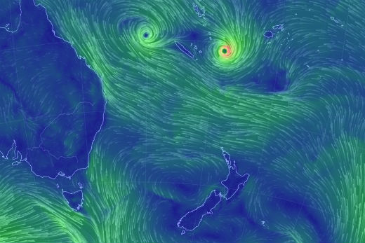
Tropical cyclones Tatiana and Winston today. Picture: Earthwind.
Philip Duncan at Weatherwatch.co.nz says the smart money is on both the cyclones breaking up as the encounter the strong easterly winds currently crossing north of New Zealand.
Winston is at this stage expected to be bounced back into the open pacific north and east of New Zealand. While Winston may strengthen to a category three strom today, it's expected to weaken to a category two by Monday.
Cyclone Tatiana, a category tow cyclone is expected to weaken to a category one storm by Sunday, and be downgraded back to a low pressure system Monday.
Swellmap is predicting the Mount Maunganui ocean beach will experience a steady 1.5m surf this week picking up Wednesday afternoon and peaking Thursday at nearly 3m – the same day Metvuw is forecasting an onshore wind of 20-25knots and heavy rain.
Philip Duncan at Weatherwatch.co.nz says the rain and wind towards the end of next week is fuelled by the masses of warm air brought south by the remnant of cyclone Tatiana.
The remains of Tatiana are expected to be amalgamated into a big low expected to move into the Tasman Sea, and from there bring rain to most of the country, affecting the north Island Wednesday, Thursday probably right through to Friday.

1 comment
drama
Posted on 13-02-2016 13:33 | By The author of this comment has been removed.
drama drama - storms have been visiting nz for thousands of yr - only just recently become "topical" because of politicised "climate change "
Leave a Comment
You must be logged in to make a comment.