A wet but mild start to the week is forecast, with moist air from the Tasman Sea hitting our shores.
However, a southerly change is expected towards the end of the week, bringing snow showers to the south and dropping temperatures back down.
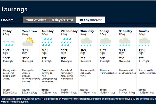
The 10-day forecast for Tauranga. Photo: MetService.
A strong northwesterly flow predominates the first half of next week producing periods of strong to gale northwesterlies in the east.
MetService is predicting mostly rain for Tauranga, with the 10-day forecast predicting showers and periods of heavy rain over the region.
The warmest day of the week is expected to be Monday, August 3, with a 17-degree high and an overnight low of 12-degrees.
The coldest nights are predicted for the end of the week, with an overnight low of three-degrees on Friday and two-degrees on Saturday and next Sunday.
Today's forecast is cloudy with occasional drizzle and light winds. There is a high of 17-degrees and an overnight low of 10-degrees.
In addition, a series of fronts moving up the country will bring rain to the south and west of the South Island, and to most of the North Island.
The heaviest rain is forecast for western areas and the north of the North Island. Warnings and watches are already in place for many areas.
Temperatures will be fairly mild across the country in the first half of the week, with Christchurch approaching 20C on Monday.
However, the flow will turn southerly towards the end of the week bringing an icy blast from the Antarctic by the weekend and snow flurries to the south.
Unsettled weather is expected over New Zealand for the coming week, with a series of troughs moving across the country. Strong moist northwesterlies predominate, but a cold southwesterly is expected to arrive late Friday.
Periods of rain persist about western areas, with occasional periods of strong to gale northwesterlies in the east. Mild temperatures in the east.
A Watch and warning are currently in force for heavy rain during Monday and Tuesday about many western parts of the South Island and lower North Island.
From Tuesday, an active front over the upper South Island is expected to move slowly northeast before becoming slow moving from about Northland to Bay of Plenty during Wednesday and early Thursday.
There is a high confidence of heavy rain about northern Westland and Buller, including the Canterbury Headwaters and Tararua Range, and a moderate confidence about the Nelson Ranges, Marlborough Sounds, Kapiti, Taranaki, Waitomo and the central high country on Tuesday.
Further north, there is a low risk about Northland, Auckland, Coromandel Peninsula, Waikato, Bay of Plenty and Taupo on Tuesday, but a moderate risk from Wednesday to Thursday.
In addition, in the strong northwesterly flow, there is a moderate risk that northwest gales will reach severe gale about the Marlborough Sounds, Wellington, Wairarapa and Hawkes Bay during Tuesday, then Gisborne late Tuesday and early Wednesday.
On Wednesday, moist northwesterlies return to the South Island, with a trough moving northeast on Thursday. There is a low confidence that rainfall accumulations will reach warning criteria in Fiordland and Westland south of Otira during this time.
There is some uncertainty for Friday, but at this stage, colder showery southwesterlies are forecast to spread over the South Island. Snow is possible to low levels about Fiordland and Southland, with a low risk of heavy snow above 300m.
Keep up to date with the latest forecasts and any watches/warnings at metservice.com or on mobile devices at m.metservice.com.
You can also follow our updates on MetService TV, at MetService New Zealand on Facebook, @metservice on Twitter and at blog.metservice.com

0 comments
Leave a Comment
You must be logged in to make a comment.